Fine days and rainy days 15.07.16
Faeroes
- Wind
- Southeasterly becoming cyclonic, mainly southwesterly later, 5 to 7.
- Sea state
- Slight or moderate, becoming moderate or rough.
- Weather
- Rain, fog patches developing.
- Visibility
- Moderate or good, occasionally very poor.
But first I return to my yesterday.
The mountains I have come from have reached 700-800m, indeed the lonely, remote 'barracks' like hostel that I planned to stay at, sat at the foot of a 764m peak whereas here on Sudoroy, peaks are generally 500-600m.
A beautiful walk from behind Tvøroyri is described initially as easy along road or footpath, with the remaining two thirds as fairly easy mountain walk to local peak Hvannhagi. With a total return length of 4.2k, a height of 483m, a stunning viewing point three quarters of the way along the mountain walk section, I think this is probably manageable and am keen to explore the pool at the top.

Looking at the map today, to get that data, I can see where I went wrong. It is the mountain walk that is 4.2k with the easy access 'road' leading towards it 1.4k each way giving a total of 7k once I get to the start. Not exceptional in itself, but a 3.6k ascent and descent is not something my left knee appreciated and it has been ache ache aching all night. I have been trying not to whinge about my knee but in truth I have been anxious much of the time when walking rough, rocky ascents and working long, long days on my feet all day.
Needing to climb very swiftly behind the town to get to the start of the easy section, I look for the steps and small copse or 'plantation'. Getting started on a route is often something I find the most difficult and today is no exception. I zig zag across and up small roads, tracks and steps to reach the starting point, adding perhaps another kilometre of climb. For the second time in just two days I find myself trespassing. Holding on to railings to prevent myself falling in the stream, walking across trodden meadows, slipping through gaps in hedges and surely walking through people's gardens. It is unclear what is path or not. Informal, occasionally used path indeed, but nothing more. Not something I would normally choose to do but, having climbed, I am reluctant to descend only to go along and back up so I copy the route others have taken, but with my heart in my mouth for fear of getting caught.
Getting my second cup of coffee of the morning I put my fleece over my nightie, socks on my feet, make my bed, tidy my desk and sit down to write. I've never had a writing desk in my bedroom before, I like this.
A woman sees me looking at the small copse and my map. my route is clear but she stops and asks where I am going. I show her my tourist map with the marked trails. She tells me I should not go through the woods but stay on the road until it ends and then turn left. I ask why not. It is better, she says. Today you take the road, tomorrow the plantation. I thank her and proceed up a very steep road but the distance is short and the woods my anchor so I'm unafraid of getting lost. I reach the track beyond the copse without difficulty, other than breathlessness, so stop to admire the view several times and watch as the 5.30pm ferry prepares to depart. I see a man haymaking in the distance and want to linger to watch him but press on, it was gone 4.30pm when I started and I have a good way to go. Another man is on a roof making repairs and again I want to watch but move on. From here on, the track is good for a while, a gentle ascent and reasonable dirt road but the high rocks beside me look formidable and for the first time I become anxious. A ram in a field beside me looks to be wearing headphones, we are both interested in each other and I wonder if he is part of the 'sheep view' project but has lost his camera!

The road soon disappears and I walk through a gate onto the fairly easy mountain walk section. I remember days ago meeting a young swiss couple who asked if I had hiking maps and books as I was out walking. I said no, I was relying on local knowledge and they told me the book was useful, I should get it, they had learned that if ever a walk said unsuitable for children under ten years it would be extremely technical, dangerous terrain. I remember this as my path disappears. I look back at my tourist map and see it just says 'fairly easy mountain walk' it doesn't say path. Nevertheless I can see the direction the route takes on the map, skirting around Skornasaklettur before climbing through what looks like a pass to the viewing spot, so I begin ascending again.
I feel dispirited. Tramping across, at times boggy, rocky terrain using just sheep trails at best, is not what I anticipated. I begin to think I will not manage but am determined to at least reach the viewing spot. I stop several times looking around for a path, thinking my route cannot be correct. When I find the path, maybe ten metres above me to my right, I am pleased and scramble up to it, determined to watch more carefully. For a while I walk more comfortably. Until I lose it again.
Around this point I remember that the forecast warned of poor visibility and rain later in the day, I regret that due to the sun and clear sky, I'm not carrying my fleece, just waterproof. I remember reading somewhere about watching for cairns and about how, in case sudden fog descends, it is not a bad idea to stop, dismantle and rebuild a cairn over and over again, to while away the time. I wish I could see cairns now and scan my immediate horizon. No cairns but I do see a small post, again some way up to my right and decide to head for it.
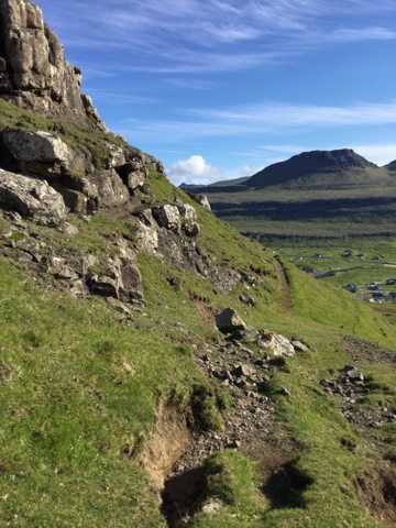
Thankfully I am back on a track again, although resembling a narrow sheep trail around steepish grassy sides with rocks looming above. I press on, afraid to look down and anxious not to stumble until I round the corner and see a small cairn, perhaps at the top of the pass. I climb to reach it. Ahead of me a broad expanse of slightly rising, rough grass with rocks and boggy sections stretches to what must, surely be the top of the pass. Birds start to call and I become anxious. Being dive bombed is not on my agenda. I reach the top of the pass and decide that this must be my viewing spot as the islands of Lítla Dímun, Stóra Dímun and perhaps Sandoy become visible.

Intended viewing spot or not, it will do. I sit on a rock from which I see people, having walked thus far alone. A group of three clambering down precarious drops from a ridge to my right and a couple, walking upwards towards me from the descent on the other side of the pass. In the distance I see what appears to be a wooden structure at the rocky edge of the land. Perhaps this is the intended viewing spot. Having made the decision not to press higher I decide i can afford to descend a little to explore this wooden structure.

The pass I have just descended

It has taken me nearly two hours to climb, what I think, has been less than 2.1k, I have been frightened, have reminded myself that I would rather die doing something exciting than just become old and decrepit, but my knee is very unhappy and I am disappointed in my ability. I had, at one point, taken out my phone, which, with location services now switched on, is allowing me to use maps. I want to find the small lake to get my bearings. It shows me a blue flashing spot for my location but a blank screen and tells me services are not available. Much later, I will discover I was on aeroplane mode, for safe saving of battery, in case I needed it in emergency.
I regret not having brought food with me and at 6.26pm, begin my ascent of the pass, then descent, happy that the way will be clearer as I descend. I am thankful the sun is still shining brightly and make my way with care. Of course, over and over, despite my attempts to watch carefully, I find myself off track and following sheep trails.

At one point I can even see why I went off trail as I climbed. Having backtracked from a vertical drop, I can see rough dips in the soggy earth, circling down to the path, no wonder I lost it at this point when ascending. I believe out of comfort zone experiences are good for the soul but I would never attempt such trails at home without an OS map and a compass, quite why I thought a glossy tourist map with thick green, blue, red and black lines marked on it might be safe. Green only I think hereon for me.

Looking now at the map and understanding the actual distances, I see I walked far off trail to my final viewing spot and estimate a total of maybe eight kilometres from my starting point in three hours. Not so bad after all.

The path through the copse, a peaceful ending.